 Every installation of the Roadsoft desktop application includes a database or access to an existing Roadsoft database, as well as a jurisdiction specific map. Roadsoft enables our customers to build and maintain a complete, detailed inventory of the thousands of transportation assets in their jurisdiction. Each interactive map contains independent but interconnected layers, called “modules”, for visually tracking collected assets. The Roadsoft desktop application also contains pavement management and analysis tools along with robust data mining features, report generation options, and external integrations making it an asset management powerhouse.
The Roadsoft desktop application contains pavement management and analysis tools, robust data mining features, fast and informative report generation options, and integration options for external information, making it an asset management powerhouse.
Roadsoft is made up of interconnected layers, called modules, which make visually tracking and recording information from thousands of assets easy. These modules enable our customers to build and maintain a complete inventory of assets. Roadsoft also serves as a centralized place to plan and record work orders for maintaining and repairing assets.
Roadsoft Features
- GIS Map Interface
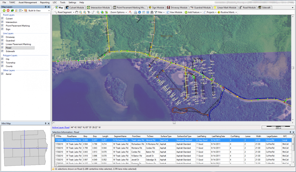
Geographic information systems (GIS) organize, analyze, and display data spatially. The Roadsoft GIS map organizes information into layers allowing the display of different data types simultaneously. All data is stored in an integrated database, meaning the data for all the layers are interconnected. This integration of data establishes relationships between the different data types making complex data analysis possible.
- Road Rating System
Roadsoft contains two evaluation systems for assessing roadway condition, Pavement Surface Evaluation and Rating system (PASER) for paved and unpaved road condition rating, and the Inventory-based Rating System™ (IBR) for unpaved road condition rating. The PASER system is a visual survey method for evaluating the condition of surface distresses, whereas the IBR system focuses on elements that do not change rapidly like surface. IBR defines a baseline condition for three characteristic elements of unpaved roads—Surface Width, Drainage Adequacy, and Structural Adequacy. With the Roadsoft software suite, our customers can use these systems to assess their roadways efficiently and cost effectively from moving vehicle.
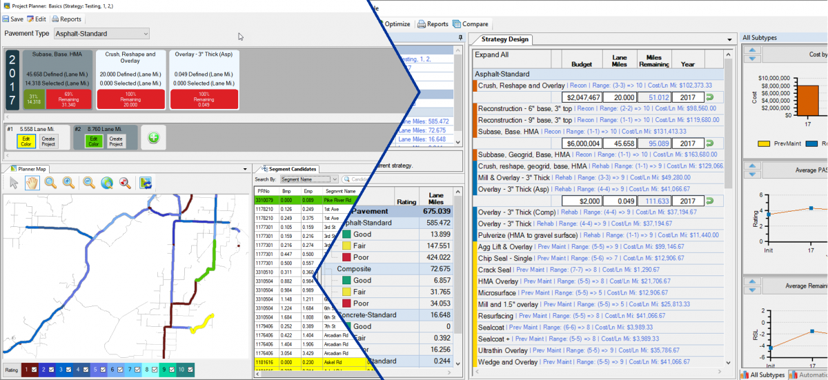
- Pavement Management and Analysis Tools
Local agencies are continually trying to do more with less, and finding the best asset management plan to fit already constrained budgets is only getting tougher. Roadsoft provides the right tools for the creation and evaluation of asset management plans, helping our customers reach end goals like not spending more money than they have to. Pavement management components in Roadsoft assist with estimating the condition of pavement assets over time, accounting for deterioration, and for developing a maintenance plan based on agency specified data and criteria. Using Roadsoft, our customers can determine the best mix of construction and maintenance activities for their networks to maximize the service life within their budgets.
- Data Mining, Report Generation and Integrations
Roadsoft can provide a clear summary of agency data through over 50 report formats. Report data are exportable into multiple file types (shapefiles, KML files, CSV files, TXT files, and XML files) for use with other database and GIS programs. Roadsoft also has integration with Google Maps and Google Earth for viewing selected data from the database in detailed panoramic views. Roadsoft’s extensive and powerful data mining features and filters combined with its reporting and integrations can give our customers comfort knowing that they are making informed decisions based on their data collection.
Roadsoft Modules
- Road Module
The Road Module is at the core of the Roadsoft asset management system. The roads serve as a backbone for all the other asset types available in Roadsoft. Our customers can track data on physical road features like pavement type, thickness, and width for lanes and shoulders. Additional tracking is available for road construction and maintenance activities as well as historical pavement condition ratings. Trackable information in the Road Module includes:
- Sign Module
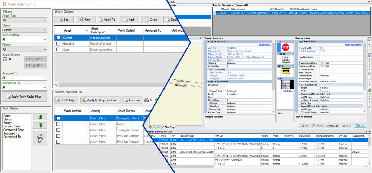
Roadway signs are crucial to road safety, and the Sign Module provides a place to record support (post) and sign information such as maintenance and inspections in addition to inventory details like material, size, and type. The Sign Module includes a full listing of signs from the Federal Manual on Uniform Traffic Control Devices (MUTCD) within its Sign Library. Customers can also record Federal Highway Administration (FHWA) required retroreflectivity ratings in the sign module. Trackable information in the Sign Module includes:
- Culvert Module
Knowing culvert size, rating, and location provides gives our customers the opportunity to prevent roadway damage or even disaster due to extreme weather events. The Culvert Module is the right tool for capturing and saving critical culvert inventory information allowing our customers to preemptively prepare for the worst and respond quickly during a weather emergency. Culvert maintenance, work orders, and stream crossing surveys are additional features available in the module. Trackable information in the Culvert Module includes:
- Point Pavement Marking Module
Pavement markings serve an essential role in conveying regulations, guidance, or warnings on paved surfaces. Roadsoft contains two separate modules for collecting and storing pavement marking data. The Point Pavement Marking Module is for collecting and storing single GPS location pavement marks such as school zones, railroad crossings, and turn arrows as well as scheduling and completing maintenance activities. Trackable information in the Point Pavement Marking Module includes:
- Linear Pavement Marking Module
Pavement markings serve an essential role in conveying regulations, guidance, or warnings on paved surfaces. Roadsoft contains two separate modules for collecting and storing pavement marking data. The Linear Pavement Marking Module is for collecting and storing longitudinal pavement markings (milepoint to milepoint) including edge lines, passing zones and other centerlines. Linear marking characteristics, projects, and inspections are all recordable in this module. Trackable information in the Linear Pavement Marking Module includes:
- Driveway Module
Road construction and maintenance projects should include the size and location of driveways for expense planning. The Driveway Module gives our customers the advantage for project planning with its options for collecting and storing locations, type, size, and culvert information for public and private driveways. Trackable information in the Driveway Module includes:
- Guardrail Module
Meeting federal requirements for guardrail design and use are an important part of roadside control. The Guardrail Module keeps information on guardrail inspections and maintenance while providing a reliable way to schedule any necessary repair or replacement work. Trackable information in the Guardrail Module includes:
- Sidewalk Module
Although Federal regulations do not require local agencies to build sidewalks, accessible pedestrian facilities within a jurisdiction provide safety to its citizens. The Sidewalk Module is for tracking the location, physical characteristics, obstructions, and condition of sidewalks providing a means for identifying sections of sidewalks that need replacing or upgrading. Trackable information in the Sidewalk Module includes:
- Drainage Structure Module
From monitoring cleanouts to identifying criticality, the Drainage Structure Module is useful for monitoring, evaluating, and reporting on the asset location, features, assessment, and activities related to drainage structures of all types. Trackable information in the Drainage Structure Module includes:
- Traffic Count Module
Predicting which roads will be busy and in need of maintenance is a challenge. Traffic counts make this task easier by providing precise information about the volume of vehicles using a road. Roadsoft's Traffic Count module lets you enter data from both automatic and manual (staff conducted) traffic counts. Using this information, you can create reports to submit to the Highway Performance Monitoring System (HPMS) and make decisions on which roads should receive priority for maintenance and safety countermeasures. Information tracked using the Traffic Count Module includes:
- Traffic Signal Module
Road intersections can be busy with traffic signals, poles, signs, cameras, and other devices set up around them to monitor and assist traffic. Knowing the location and condition of these devices is useful when planning maintenance and construction for both the traffic signals and the roads around them. Roadsoft’s Traffic Signal module allows users to record information about the placement, specifications, and condition of traffic signals and other devices. Information tracked using the Traffic Signal Module includes:
- Crash Module *
Roadsoft's Crash module allows you to review and analyze imported crash data in conjunction with Roadsoft's Safety Analysis tools. It allows you to analyze up to 10 years of crash data taken from redacted incident reports. This information can be used to make safety improvements to your jurisdiction’s road design and operations. Information available in the Crash Module could include: